A few months ago, we kicked off a project to explore what it would take to create an air corridor between NASA Ames and UC Berkeley using electric vertical takeoff and landing aircraft, or eVTOLs. Since then, we’ve made real progress on figuring out what those flights might look like and how they could realistically work.
In this update, we are going to walk through what we’ve done so far — including the different flight routes we tested, how we used flight simulators to model them, and where the landing pads (or vertiports) could go. The big idea is still the same: can we safely and efficiently fly people or packages between Silicon Valley and Berkeley?
Choosing Routes Based on VFR Flight Maps
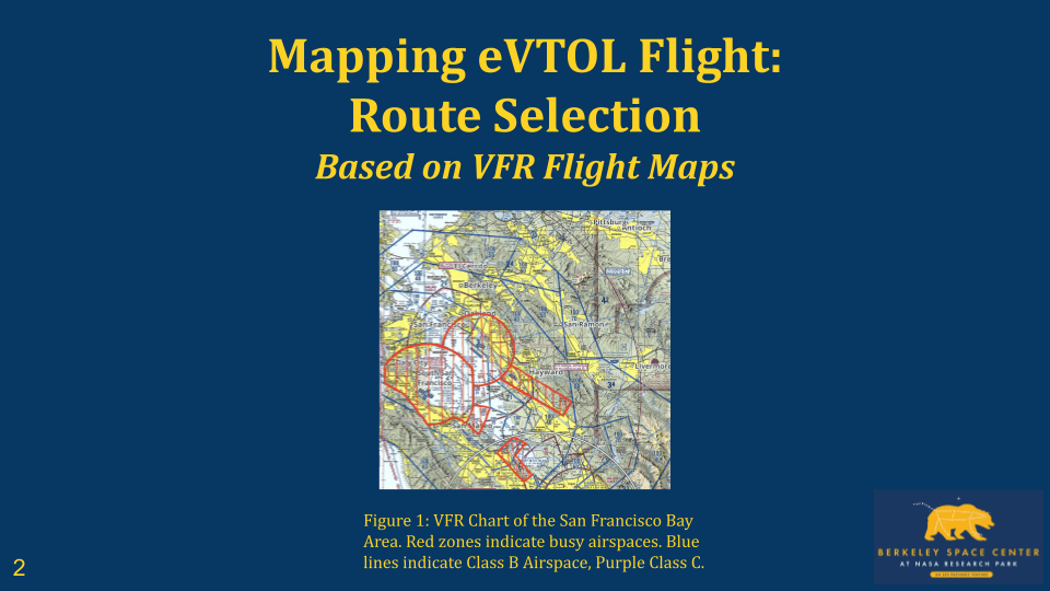
Our first step was figuring out the different ways we could fly from Moffett Field (KNUQ) to Berkeley while following VFR (Visual Flight Rules). That means we’d be flying by sight, not instruments, so we had to stay clear of restricted or busy airspace.
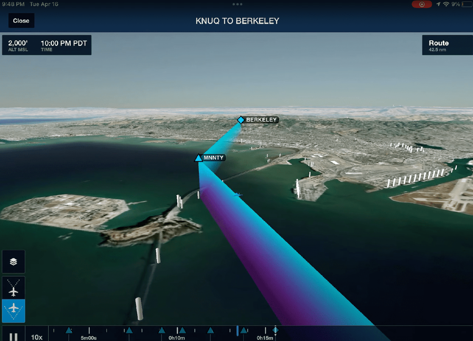
After looking at flight maps, we picked three possible routes: a West Route, an East Route, and a San Francisco (SF) Route. The West Route stays along the bay and avoids a lot of traffic. The East Route flies over the hills. And the SF Route goes around the Peninsula and through the city.

The “West Route”
Google Maps view of the Bay area. Port Location at Berkeley and KNUQ Airport at Moffett Field. Route in cyan and purple from Berkeley to KNUQ, altitudes include at different ascension points.

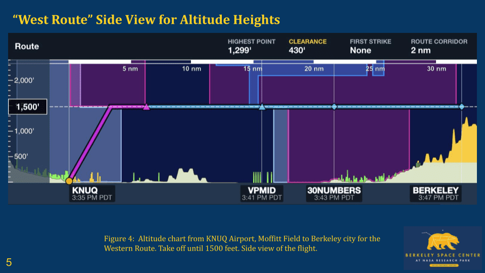
Altitude chart from KNUQ Airport, Moffitt Field to Berkeley city for the Western Route. Take off until 1500 feet. Side view of the flight.
The “East Route”
Google Maps view of the Bay area. Port Location at Berkeley and KNUQ Airport at Moffett Field. Eastern route over the mountains. Climb May Be a Bit Slower; Route Remains Unaffected.

Altitude chart from KNUQ Airport, Moffitt Field to Berkeley city for the Eastern Route. Take off until 1500 feet. Side view of the flight.

The “SF Route“
Route through San Francisco, displayed on a VFR Flight Chart in cyan.

Google Maps view of the SF Route.

Altitude chart from KNUQ Airport, Moffett Field to Berkeley city for the SF route. Take off until 1500 feet. Side view of the flight.

Testing Each Flight Path in Google Earth and X-Plane
We used Google Earth and X-Plane flight simulator to model each of these paths. That helped us test altitude changes, see the terrain, and get a better sense of what a real eVTOL pilot would experience.

For the West Route, we modeled takeoff and climb from KNUQ up to around 1500 feet, staying mostly over water. The East Route had a similar profile but climbed a bit slower since we’d be going over higher ground. The SF Route had the most altitude changes and was probably the most complex — especially when it came to dealing with controlled airspace and Class B boundaries.
We ended up favoring the West Route. It’s the most direct and has the fewest potential conflicts with airport traffic. It also gives us more room to descend near Berkeley and doesn’t require steep climbs.
Simulating the Joby S4
To make things more realistic, we also looked at the Joby S4, one of the most promising eVTOL prototypes out there. We used a 3D model of the aircraft and ran flight simulations over the Moffett Field runway. The goal wasn’t just to map the route — it was to test what an actual flight could look like using aircraft designed for urban mobility.
See the video:
Finding Landing Spots in Berkeley
(Insert Slides 13–17 as images in order)
Flight paths are one thing. But eVTOLs also need somewhere to land. So we spent time identifying possible vertiport locations in Berkeley. We focused on sites that are close to public transportation and within walking distance of key campus buildings.

Our top candidate is University Hall. It’s one block from the BART station and the UC Davis shuttle stop, and it’s right near the 51B bus route. From there, you can easily walk to most of the engineering campus, including places like Sutardja Dai Hall and CITRIS.

We also looked at the UC Berkeley Space Center, which would be a great landing site once it’s fully developed. It’s located closer to the edge of campus and has space for infrastructure, but for now, University Hall is probably more practical.

We used Google Earth to create 3D renderings of each location, which helped us figure out how the landing sites might fit into the city and how people would get to and from the aircraft.
What We’ve Learned So Far
After running all these simulations and models, we’ve confirmed that flying eVTOLs between NASA Ames and Berkeley is definitely possible — at least on paper. The West Route looks like the best option right now, and University Hall could work as a first-gen vertiport.
There’s still a long way to go. We’d need approval from air traffic control, noise and safety studies, and probably a lot of collaboration with people from NASA, Berkeley, and the FAA. But as a concept, it’s starting to feel more real.
Looking Ahead
Next, we want to test the route in real-time VFR conditions and start talking to some of the local air traffic controllers. We’re also hoping to get more feedback from experts in urban air mobility and maybe even reach out to Joby Aviation.